
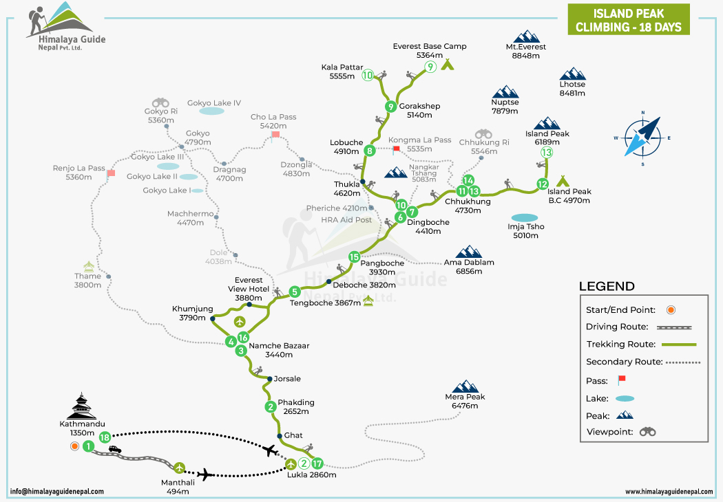
The EBC Trek with Island Peak Climbing Map shows two different parts of the adventure in one picture. Instead of viewing the trek and climbing section separately, the map shows how the route takes you from the lower Khumbu area to the high-altitude climbing sections around Chhukung and Island Peak. The map is especially useful before the adventure because it gives a realistic sense of how the journey changes each day and takes you through different sections.
For trekkers planning the Island Peak Climbing, this map serves as a visual guide. Island Peak Climbing map shows key locations, geographic features & major highlights for a better trekking experience. It’s downloadable so that you can use it offline on the route. You can also zoom in and out to view specific areas of the map in greater detail.
Island Peak Climbing Map Info Brief
| Route Details | Information |
|---|---|
| Trek Duration | 18 days |
| Starting Point | Kathmandu |
| Trek Starting Point | Lukla (2,860 m) |
| Main Route | Lukla → Phakding → Namche Bazaar → Tengboche → Dingboche → Lobuche → Gorakshep → Everest Base Camp |
| EBC Elevation | 5,364 m |
| Highest Point on EBC Section | Kala Patthar – approximately 5,550–5,555 m |
| Island Peak Route | Chhukung → Island Peak Base Camp → Island Peak Summit |
| Island Peak Base Camp | 4,970 m |
| Highest Point of the Combined Journey | Island Peak Summit (6,189 m) |
| Major Acclimatization Stops | Namche Bazaar and Dingboche |
| Major Viewpoints | Everest View Hotel, Kala Patthar and Chhukung area |
| Major Peaks Seen | Everest, Lhotse, Nuptse, Ama Dablam, Island Peak and Makalu |
| Return Route | Island Peak → Chhukung → Dingboche/Pangboche → Namche Bazaar → Lukla → Kathmandu |
Island Peak Climbing Map Route
| Route | Duration | Distance |
|---|---|---|
| Day 01: Arrival in Kathmandu | — | — |
| Lukla → Phakding | 3–4 hrs | ~8 km |
| Phakding → Namche Bazaar | 6–7 hrs | ~10–11 km |
| Acclimatization in Namche Bazaar | — | Optional hike |
| Namche Bazaar → Tengboche | 5–6 hrs | ~10 km |
| Tengboche → Dingboche | 5–6 hrs | ~11 km |
| Acclimatization in Dingboche | — | Optional hike |
| Dingboche → Lobuche | 5–6 hrs | ~8–9 km |
| Lobuche → Everest Base Camp → Gorakshep | 6–7 hrs | ~11 km |
| Gorakshep → Kala Patthar → Dingboche | 6–7 hrs | ~12–13 km |
| Dingboche → Chhukung | 2–3 hrs | ~4 km |
| Chhukung → Island Peak Base Camp | 3–4 hrs | ~3–4 km |
| Island Peak Base Camp → Summit → Chhukung | 10–14 hrs | ~12–14 km |
| Extra/Contingency Day | — | — |
| Chhukung → Pangboche | 4–5 hrs | ~7–8 km |
| Pangboche → Namche Bazaar | 5–6 hrs | ~12–13 km |
| Namche Bazaar → Lukla | 6–7 hrs | ~18–20 km |
| Lukla → Kathmandu (flight) | — | — |
How to Read an EBC with Island Peak Climbing Map?
The legend plays a vital role in reading the EBC Trek with Island Peak Climbing map. It explains what each line, color, and symbol represents, making it easier to understand the route and surrounding geographical features.
| Symbol | Meaning | What it shows on the map | Details |
|---|---|---|---|
| The orange circle | Starting or finishing location | Where the overall journey begins or ends | Kathmandu |
| The black and white dashed line | Road/vehicle route | Sections traveled by bus, jeep, or other vehicle | Kathmandu to Manthali |
| The green solid line | Main trekking trail | The primary walking route of the trek | Lukla→ Phakding→ Namche Bazaar→ Tengboche→ Dingboche→ Lobuche→ Gorakshep→ Everest Base Camp→ Kala Patthar→ Chhukung→ Island Peak Base Camp→ Island Peak Summit→ Chhukung→ Pangboche→ Namche Bazaar→ Lukla |
| The dotted gray line | Alternative trail | Optional or less-used trekking routes connected to the main trail | Chhukung to Lobuche via Kongma La, Chhukung Ri |
| The red flag | Mountain pass | A high crossing point between valleys or mountains | Not included in this journey |
| The blue oval represents a lake | Lake | Natural lakes along or near the trekking route | Imja Tsho |
| The mountain sign | Mountain peak | Major peaks visible or located near the route | Island Peak, Nuptse, Lhotse, Mount Everest, Ama Dablam, and Mera Peak |
| The binocular symbol | Viewpoint | Places marked for panoramic mountain or landscape views | Everest View Hotel and Kala Patthar |
EBC and Island Peak Route Connection on the Map
The EBC and Island Peak routes are not two completely separate trails. As you can see on the map, they share most of the same trekking route through the Everest region and connect near Dingboche and Chhukung. This is what makes it possible to combine the Everest Base Camp trek with Island Peak climbing in one journey.
Starting from Lukla, the route follows the main Everest trail through Phakding, Namche Bazaar, Tengboche, and Dingboche. From Dingboche, trekkers continue toward Lobuche, Gorakshep, and Everest Base Camp. The map’s numbered points help you follow this section step by step.
After reaching Everest Base Camp, the route continues to Kala Patthar, one of the best viewpoints for seeing Everest and the surrounding mountains. You then return toward Dingboche. This is where the map becomes especially important, as the route turns toward Chhukung, the gateway to Island Peak.
From Chhukung, the trail becomes the Island Peak climbing section. It continues to Island Peak Base Camp, then up to the 6,189 m summit of Island Peak. After completing the climb, the route returns to Chhukung and eventually reconnects with the main Everest trail for the journey back toward Namche Bazaar and Lukla.
EBC with Island Peak Climbing Map FAQs
What does the EBC with Island Peak Climbing Map show?
Where does the EBC route connect with the Island Peak route?
What is the highest point shown on the EBC and Island Peak map?
How does the map show the daily itinerary?
How far is Island Peak from Everest Base Camp on the map?
Which is the most important junction on the EBC with the Island Peak map?

Related Trips of Island Peak Climbing Map

Island Peak Climbing | 18 Days Itinerary At $2,195


Everest Base Camp Trek
The Everest Base Camp trek is one of the most popular treks in Nepal. The trek is more frequently visited than other popular treks, such as the Annapurna Base Camp Trek or the Langtang Valley Trek, which are also well-known among trekkers worldwide. The trek is on the bucket list for many trekkers to reach the base of the world’s highest peak, Mount Everest. Everest Base Camp trek begins with a Kathmandu to Lukla flight & provides a challenging Himalayan & Sherpa village experience costing you $955. The paths twist and turn through beautiful Sherpa villages, high rhododendron forests, and alongside the Dudh Koshi River, offering glimpses of the local culture and the strong presence of the local people.

As the altitude gradually increases from Lukla, you will pass through Namche, Tengboche, and Dingboche. During this trek, trekkers need to acclimatize to the conditions of the Khumbu region. During these treks, trekkers will enjoy stunning views of mountains such as Everest, Ama Dablam, Nuptse, Lhotse, and Cho Oyu. The final section of your walk takes you to Gorak Shep, the last place before you reach Everest Base Camp, at an altitude of 5,364 meters. From Gorak Shep, you will walk to the highest point of the trek, at 5,644 metres, Kala Patthar. This is a rewarding trek, one that provides an immense sense of accomplishment and offers wonderful views of Mount Everest and the Khumbu Icefall up close, which will stay with you forever.
Everest Base Camp Trek CostThe Everest Base Camp Trek cost ranges from USD 1,055 to USD 1,510 per person for a standard package. The cost of the trek to EBC varies based on various factors like group size, trek duration, accommodation, transportation, services included, and customization of the trip. Also, the standard trek package covers most of the expenses required for the trek, including meals and accommodation, permits, guide service, domestic flight ticket, overland transportation, and necessary government taxes.
Everest Base Camp Trek Cost Breakdown:
| Category | Description | Estimated Cost (USD) | Factors Influencing Cost |
|---|---|---|---|
| Permits | Fees are required to trek in the Everest region. | $50 – $60 |
|
| Transportation | Costs to reach the trek starting point (usually Lukla) and return to Kathmandu. | $360 – $460 |
|
| Accommodation | Cost of staying in tea houses/lodges along the trekking route and hotels in Kathmandu. | $150 – $500+ |
|
| Food & Drinks | Expenses for meals (breakfast, lunch, dinner) and beverages during the trek. | $250 – $500+ |
|
| Guides | Fees for hiring a licensed trekking guide. | $500 – $1000+ |
|
| Trekking Gear | Costs for essential trekking equipment. | $100 – $500+ (if renting) / $300 – $2000+ (if buying) |
|
| Visa | Nepal entry visa fees. | $30 – $125 |
|
| Travel Insurance | Mandatory insurance that covers medical emergencies, high-altitude sickness, and emergency evacuation (including helicopter rescue). | $100 – $300+ | Cost depends on the duration of the trek and the coverage provided by the insurance policy. Ensure it specifically covers trekking at altitudes up to 6,000 meters. |
| Miscellaneous | Personal expenses such as hot showers, Wi-Fi, charging electronic devices, snacks, souvenirs, and tips for guides and porters. | $100 – $300+ |
|

