Discover the Real Himalayas with Trusted Local Guides & Porters for 2026/2027.
Annapurna Photo Tour
Country
Nepal
Difficulty
Moderate
Trek Duration
12
Best Season
Spring (Mar - May) & Autumn (Sept - Nov)
Accommodation
Lodge, Guest House, Hotel
Start / End Point
Kathmandu - Kathmandu
Max. Altitude
Annapurna Base Camp (4,130 M)
Group Size
1 - 25
Meals Included
Breakfast, Lunch, Dinner
Acclimatization
Included In Itinerary (Ghorepani & Annapurna Base Camp)
Permits
Annapurna Conservation Area Project Permit & TIMS Card
Recommended For
Beginner, Medium Level Trekkers
Duration
15 Days
Activity
Photo Travel in Nepal
Nature Of Trek
Lodge to Lodge Trekking
Activity Per Day
4 - 6 Hours walking
Transportation
Flight, Jeep, Deluxe Tourist Bus
Distance
Annapurna Photo Tour Overview
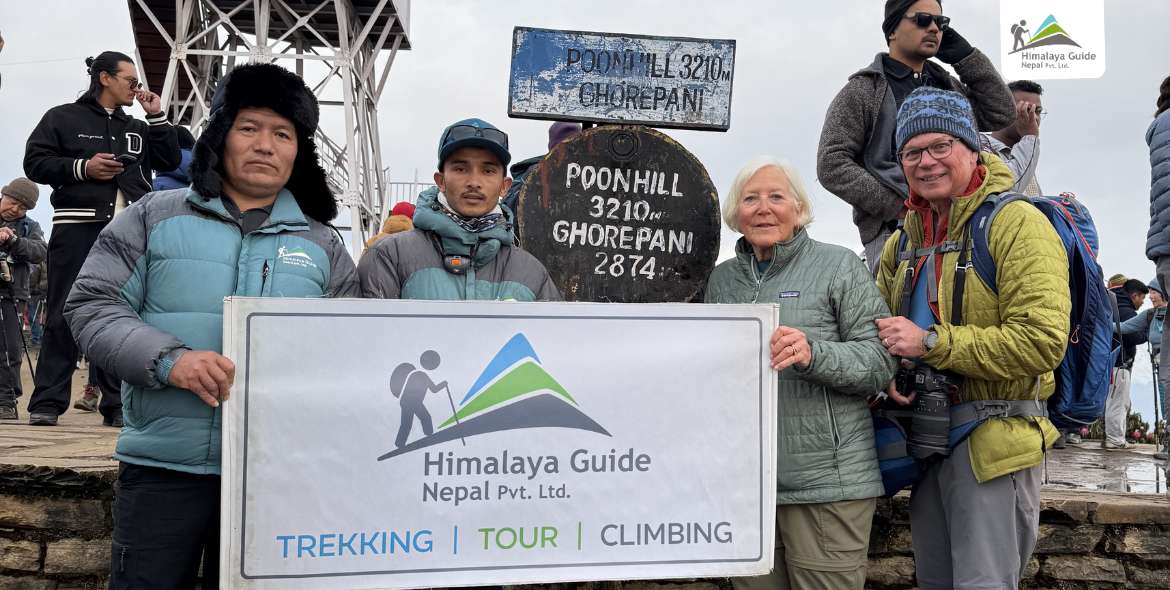
The Annapurna Photo Tour is a unique journey that combines trekking in the Himalayas with guided photography. It is designed for travelers who enjoy capturing landscapes, mountains, and local culture through their cameras. This itinerary focuses on the best times for photography, especially sunrise and sunset at famous viewpoints like Poon Hill and Annapurna Base Camp, when the mountains look most beautiful. With experienced guides who understand the terrain and lighting, you can photograph the stunning Himalayan scenery and the daily life of local communities.
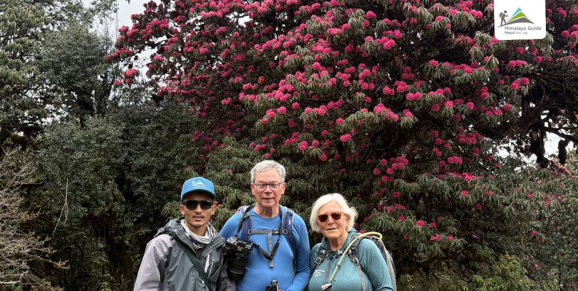
The tour is carefully organized to support photography along the trek. Instead of rushing from one place to another, the schedule allows enough time to stop, observe, and take photos. The journey also includes cultural experiences, including visits to historic sites in Kathmandu, and the peaceful scenery around Pokhara. Thus, this balanced itinerary makes the tour a great choice for travelers who want to enjoy a Himalayan adventure while building a memorable photography collection.
Annapurna Photo Tour Highlights
- Capture breathtaking 360-degree sunrise panoramas from the famous viewpoint at Poon Hill.
- Photograph the massive 8,000-meter peaks of the Annapurna Massif, high above the surrounding valleys.
- Document the authentic stone houses and the everyday lifestyle of traditional Gurung villages along the trekking route.
- Explore beautiful rhododendron forests and dramatic river gorges that shape the landscape along the trail.
- Capture clear views of the sacred “Fishtail” mountain, Machhapuchhre, from its scenic base camp.
- Experience the spectacular Himalayan amphitheater surrounded by giant peaks at Annapurna Base Camp.
- Witness the calm reflections of snow-covered mountains on the peaceful waters of Phewa Lake.
- Discover the rich Newari art, architecture, and craftsmanship at UNESCO World Heritage sites in Kathmandu.
Annapurna Photo Tour Outline Itinerary
| Route | End Elevation | Elevation Gain/Loss | Duration | Distance |
|---|---|---|---|---|
| Day 01 Arrival at the International Airport in Kathmandu, Nepal | 1,400 M | |||
| Day 02 Drive from Kathmandu to Pokhara by Bus | 822 M | - 578 M | 6 - 8 Hours Driving | Approx. 200 KM |
| Day 03 Drive from Pokhara to Birethanti and Trek to Ulleri | 1,960 M | + 1,138 M | 5 - 6 Hours Trekking | 10 - 12 KM |
| Day 04 Trek from Ulleri via Banthanti to Ghorepani | 2,860 M | + 900 M | 4 - 5 Hours Trekking | 8 - 10 KM |
| Day 05 Sunrise Hike to Poon Hill and Explore Ghorepani | 2,860 M | + 350 M | 2 - 3 Hours Trekking | 3 - 5 KM |
| Day 06 Trek from Ghorepani via Banthanti to Tadapani | 2,630 M | - 230 M | 5 - 6 Hours Trekking | 9 - 11 KM |
| Day 07 Trek from Tadapani via Chule and Gurjung to Chhomrong | 2,170 M | - 460 M | 5 - 6 Hours Trekking | 10 - 12 KM |
| Day 08 Trek from Chhomrong via Sinuwa to Bamboo | 2,310 M | + 140 M | 4 - 5 Hours Trekking | 8 - 10 KM |
| Day 09 Trek from Bamboo via Dovan and Himalaya to Deurali | 3,230 M | + 920 M | 5 - 6 Hours Trekking | 9 - 11 KM |
| Day 10 Trek from Deurali via MBC to Annapurna Base Camp | 4,130 M | + 900 M | 5 - 6 Hours Trekking | 8 - 10 KM |
| Day 11 Trek from ABC via MBC and Himalaya to Bamboo | 2,310 M | - 1,820 M | 7 - 8 Hours Trekking | 13 - 15 KM |
| Day 12 Trek from Bamboo via Chhomrong to Jhinu Danda | 1,780 M | - 530 M | 5 - 6 Hours Trekking | 9 - 11 KM |
| Day 13 Trek from Jhinu Danda via Landruk and Tolka to Pothana | 1,890 M | + 110 M | 5 - 6 Hours Trekking | 10 - 12 KM |
| Day 14 Trek from Pothana via Dhampus and Phedi to Pokhara | 822 M | - 1,068 M | 3 - 4 Hours Trekking | 6 - 8 KM |
| Day 15 Drive from Pokhara to Kathmandu by Deluxe Tourist Bus | 1,400 M | + 578 M | 6 - 8 Hours Driving | Approx. 200 KM |
Annapurna Photo Tour Detailed Itinerary
Arrival at the International Airport in Kathmandu, Nepal
Trek Distance
1,400 M
Your journey starts the moment you land at Tribhuvan International Airport (TIA), where a representative from Himalaya Guide Nepal greets you and helps with all arrival procedures. You are then transferred to your hotel in Kathmandu, where you check in and take some time to unwind. Once settled, you attend a short briefing session to get all the key details about the photography tour and the trek ahead.
The rest of the day is free for you. Use this time to set up your camera gear and prepare for the Annapurna adventure photography trip ahead. Later, you can explore Kathmandu’s bustling streets, colorful markets, and rich culture at your own pace. In the evening, you enjoy a welcome dinner featuring traditional Nepali cuisine, marking a wonderful start to your Annapurna adventure.
Drive from Kathmandu to Pokhara by Bus
Drive Distance
204 KM
Drive Duration
6 - 8 Hours
Highest Altitude
1,400 M
Place
Pokhara
Meals
Breakfast, Lunch, Dinner
Accommodation
Hotel
On this day, you leave Kathmandu early in the morning and travel to Pokhara by bus along the Prithvi Highway. On the way, you see the beautiful Trishuli River and the green hills of Dhading, as well as small villages like Galchhi and Muglin. After a while, you stop for lunch at a local restaurant in Kurintar, where you can enjoy fresh Nepali dishes or other meal options while taking in the peaceful countryside.
After lunch, you continue your journey through the Marsyangdi River Valley and arrive in Pokhara by late afternoon. Once in the city, you check into your hotel, relax, and get ready to enjoy the calm beauty of this lakeside town. In the afternoon, you have your first chance to explore the Annapurna region and photograph the sunset over Phewa Lake, with the stunning Machhapuchhre peak in the distance.
Drive from Pokhara to Birethanti and Trek to Ulleri
Trek Distance
10 - 12 KM
Trek Duration
5 - 6 Hours
Drive Distance
45 KM
Drive Duration
1 - 2 Hours
Highest Altitude
1,960 M
Place
Ulleri
Meals
Breakfast, Lunch, Dinner
Accommodation
Lodge, Guest House
Today, you take a scenic drive from Pokhara through Nayapul to Birethanti, the official starting point of your Annapurna photography trek. The trail begins in lush green surroundings as you cross the Modi Khola on suspension bridges and pass through the charming villages of Sudame and Hile. Along the way, enjoy the soothing sound of Bhurungdi Khola waterfalls and take in the calm beauty of the natural landscape as you approach the foothills.
Then comes the famous Ulleri staircase, an uphill climb of over 3,000 stone steps. As you ascend, you witness beautiful views of Annapurna South and Hiunchuli rising majestically on the horizon. You pass through Tikhedhunga, a traditional Magar and Gurung village, before completing the steep climb to the Ulleri hilltop. Here, you settle in for your overnight stay, perfectly positioned to capture the golden hour light illuminating the peaks the following morning.
Trek from Ulleri via Banthanti to Ghorepani
Trek Distance
8 - 10 KM
Trek Duration
4 - 5 Hours
Highest Altitude
2,860 M
Place
Ghorepani
Meals
Breakfast, Lunch, Dinner
Accommodation
Lodge, Guest House
On Day 04, you continue your trek from Ulleri toward Ghorepani. In this section, you pass through landscapes that gradually shift into ancient rhododendron forests. The trail takes you through Banthanti, a rustic settlement tucked among cliffs and waterfalls. You can stop here for a moment to capture sunlight filtering through the dense canopy. Along the way, the gentle flow of the Bhurungdi Khola and the calm of the high-altitude wilderness create a peaceful trekking atmosphere.
As you near Nangethanti, the trail opens up and gives closer views of Annapurna South and Hiunchuli. From here, the final stretch leads you to Ghorepani, a historic Magar village famous for its blue-roofed houses and its role as a key stop on ancient trade routes. You settle into your teahouse at 2,860 meters. Perched on the hillside, it offers one of the best photo spots for dramatic sunsets over the Dhaulagiri Range, setting the stage for tomorrow’s sunrise hike to Poon Hill.
Sunrise Hike to Poon Hill and Explore Ghorepani
Trek Distance
3 - 5 Hours
Trek Duration
2 - 3 Hours
Highest Altitude
3,210 M
Place
Ghorepani
Meals
Breakfast, Lunch, Dinner
Accommodation
Lodge, Guest House
Your day begins early at 4:30 AM with a hike to Poon Hill, which sits at 3,210 meters. The air is crisp and quiet as you follow the soft light of your headlamp along the old stone steps that wind through rhododendron and oak forests. As you climb higher, the dark shapes of the Himalayas slowly appear against the starlit sky. At the top, a viewtower covered in colorful prayer flags provides a perfect spot for photos, and you can enjoy a hot cup of coffee from the local tea stand while waiting for the sunrise.
When the sun rises, you can finally see the famous golden hour light up the Annapurna Range and Dhaulagiri Range in bright orange and pink colors. After enjoying the views and capturing moments, you return to Ghorepani for a hearty breakfast. You can rest, chat, and then explore the village. You can visit the Pun Magar Museum, run by the local Mothers’ Group, to photograph traditional artifacts and learn about Magar culture. The rest of the afternoon is free to walk through the blue-roofed houses, visit the local school, and capture daily life in the village with the Himalayan peaks as your backdrop.
Trek from Ghorepani via Banthanti to Tadapani
Trek Distance
9 - 11 KM
Trek Duration
5 - 6 Hours
Highest Altitude
3,210 M
Place
Tadapani
Meals
Breakfast, Lunch, Dinner
Accommodation
Lodge, Guest House
Leaving Ghorepani, you begin a steady climb toward Deurali Pass (3,090 M). As you reach the ridge, you are greeted with the first close-up views of the Dhaulagiri and Annapurna Range. After that, the trail drops into a deep, ancient forest of moss-covered rhododendron trees. Keep your camera ready, as the Himalayan Monal sometimes flashes its rainbow-colored feathers through the misty canopy near the Banthanti waterfalls.
The path continues through a high-altitude cloud forest before reaching the small village of Tadapani (2,630 M). This spot is a photographer’s dream. From here, the summit of Machhapuchhre rises sharply right before you, unlike the distant views from previous days. Settle into your lodge, that’s more like a natural balcony for photography. You can watch the sunset behind the towering granite walls of Annapurna South and Hiunchuli, capturing the rich textures of ice and rock as the light turns deep crimson.
Trek from Tadapani via Chule and Gurjung to Chhomrong
Trek Distance
10 - 12 KM
Trek Duration
5 - 6 Hours
Highest Altitude
2,630 M
Place
Chhomrong
Meals
Breakfast, Lunch, Dinner
Accommodation
Lodge, Guest House
Today, you descend from Tadapani through a forest of rhododendron and oak, where morning sunlight creates stunning god rays, perfect for nature shots. You cross the Kimrong Khola on a suspension bridge, then climb steadily toward the twin villages of Chuile and Gurjung. At Chuile, you get your first eye-level view into the Annapurna Sanctuary, with Annapurna South towering above.
Continuing on, the trail passes terraced millet and barley fields that offer wide views of Gurung stone houses against the backdrop of Machhapuchhre. You reach Chhomrong (2,170 M), another perfect Himalayan village for spectacular views. You enjoy a close-up panorama of the Annapurna massif from your teahouse, which makes it ideal for capturing the blue hour as village lights twinkle beneath the towering peaks. Later, as night falls, this high ridge provides an incredible opportunity to photograph the Milky Way stretching above the dark silhouettes of the peaks.
Trek from Chhomrong via Sinuwa to Bamboo
Trek Distance
8 - 10 KM
Trek Duration
4 - 5 Hours
Highest Altitude
2,340 M
Place
Bamboo
Meals
Breakfast, Lunch, Dinner
Accommodation
Lodge, Guest House
The day begins with a steep descent down the famous Chhomrong stone staircase. This section gives a unique overhead view of the river valley below. Then you cross the Chhomrong Khola suspension bridge, from where you start a steady climb through lush forests and terraced fields toward Sinuwa. Along the way, you can capture the peaceful, misty atmosphere of the inner sanctuary, highlighted by waterfalls cascading over the granite cliffs of Hiunchuli.
Upon reaching Sinuwa, you can take a break and enjoy wide-angle views of the Modi Khola and the sharp spire of Machhapuchhre. Afterwards, you continue past a deep forest of bamboo and rhododendron, alongside the Modi River, to eventually reach a small settlement, Bamboo (2,310 M). Living up to its name, the teahouse is tucked deep within the canyon, surrounded by bamboo forests. This spot is ideal for macro photography of rare alpine plants and capturing the soft, filtered light as it touches the valley floor in the late afternoon.
Trek from Bamboo via Dovan and Himalayan to Deurali
Trek Distance
8 - 10 KM
Trek Duration
4 - 5 Hours
Highest Altitude
3,230 M
Place
Deurali
Meals
Breakfast, Lunch, Dinner
Accommodation
Lodge, Guest House
On Day 09, you climb steadily from Bamboo to Deurali, winding through the lush high-altitude forests of the Annapurna region. You pass through Dovan, a serene settlement embraced by towering granite cliffs and cascading waterfalls. As you ascend, the vegetation thins and reveals breathtaking low-angle views of Fishtail (Machhapuchhre) rising dramatically above the landscape.
A stop at Himalaya (2,920 M) gives you a chance to rest and drink in panoramic vistas of snow-covered peaks. Continuing onward, you pass the historic Hinku Cave, where porters, local shepherds, and early trekking expeditions used to rest. From here, you enter the rugged alpine zone before reaching Deurali (3,200 M), the gateway to the Annapurna Sanctuary. At the village, the roaring Modi Khola cuts a deep gorge below, while giant mountains rise around you. It’s a view that stays with you long after you leave the place.
Trek from Deurali via MBC to Annapurna Base Camp
Trek Distance
9 - 11 KM
Trek Duration
5 - 6 Hours
Highest Altitude
4,130 M
Place
Annapurna Base Camp
Meals
Breakfast, Lunch, Dinner
Accommodation
Lodge, Guest House
This day marks the highlight of your Annapurna photography trek. You move from Deurali into the heart of the Annapurna Sanctuary, where a climb takes you through rugged alpine terrain. From here, forests vanish and give way to massive rock walls and the glacial moraine of the Modi Khola. Towering peaks of the Annapurna Massif surround you, with the legendary south face of Annapurna I dominating the skyline.
You pass Machhapuchhre Base Camp (MBC) at 3,700 M, a serene spot offering a close-up, vertical view of the iconic Fishtail peak. Continuing your final ascent, you eventually reach Annapurna Base Camp (ABC) at 4,130 M. Here, a 360-degree amphitheater of peaks, including Annapurna South, Hiunchuli, and Gangapurna, unfolds before you. Additionally, this high-altitude sanctuary is perfect for sunset and astrophotography, as stars glimmer against the backdrop of glaciers in complete Himalayan silence.
Trek from ABC via MBC and Himalayan to Bamboo
Trek Distance
13 - 15 KM
Trek Duration
7 - 8 Hours
Highest Altitude
4,130 M
Place
Bamboo
Meals
Breakfast, Lunch, Dinner
Accommodation
Guest House
After a memorable day of exploring Annapurna Base Camp, you begin your descent toward Bamboo. You retrace the familiar trail through MBC and the rugged Himalayan landscape. Leaving behind the breathtaking amphitheater of peaks and the towering south face of Annapurna I, the journey starts with a sense of accomplishment as the quiet beauty of the sanctuary slowly fades behind you.
As you descend, the terrain gradually transforms. The alpine meadows and glacial moraine paths lead to the lush rhododendron forests below. You can stop at MBC (3,700 M) for a final close-up view of Fishtail Peak before continuing down through Deurali and Himalaya. By the time you reach Bamboo (2,310 M), the air feels much warmer and thicker. Spend the night in the surrounding forest, which creates a peaceful setting for rest.
Trek from Bamboo via Chhomrong to Jhinu Danda
Trek Distance
9 - 11 KM
Trek Duration
7 - 9 Hours
Highest Altitude
2,310 M
Place
Jhinu Danda
Meals
Breakfast, Lunch, Dinner
Accommodation
Lodge, Guest House
Continuing from Bamboo, you continue your journey to Jhinu Danda through the village of Chhomrong. The trail passes through rhododendron forests and bamboo groves that form a green tunnel scenery along the path. The walk also offers clear views of the surrounding valleys and distant peaks such as Annapurna South and Hiunchuli.
At Chhomrong, you take a short rest and enjoy the wide mountain views from this hillside village. After the break, you follow a steep trail of stone steps down to Jhinu Danda at 1,780 M. The highlight of the day is the natural hot springs near the Modi Khola, just 15 minutes away from the main village. Here, a warm bath in the mineral water helps relax your tired muscles after the long photography workshop trek.
Trek from Jhinu Danda via Landruk and Tolka to Pothana
Trek Distance
9 - 11 KM
Trek Duration
5 - 6 Hours
Highest Altitude
1,890 M
Place
Pothana
Meals
Breakfast, Lunch, Dinner
Accommodation
Lodge, Guest House
On this day, you leave Jhinu Danda and cross the longest suspension bridge in the region, Jhinu-Samrung Suspension Bridge (also known as the Kadoorie Bridge). The bridge stands high above the Modi Khola and gives you a wide view of the river far below. The trail then leads through green forests and terraced fields toward the village of Landruk. This beautiful Gurung village has stone paths and traditional slate-roofed houses. It is a great place to observe local life with Annapurna South and Hiunchuli rising in the background.
The journey continues through the village of Tolka, where open viewpoints reveal the surrounding valleys and green hills. After this, you walk toward Pothana at 1,890 meters. The trail passes through a quiet forest area known for its cool air and birdlife. By late afternoon, you reach the peaceful village of Pothana. From here, you enjoy a clear view of the Machhapuchhre (Fishtail) peak and spend a calm final night in the mountains.
Trek from Pothana via Dhampus and Phedi to Pokhara
Trek Distance
10 - 12 KM
Trek Duration
5 - 6 Hours
Drive Distance
18.7 KM
Drive Duration
30 - 45 Minutes
Highest Altitude
1,890 M
Place
Pokhara
Meals
Breakfast, Lunch, Dinner
Accommodation
Lodge, Guest House
Today marks the final trekking day of your Annapurna photography tour in Nepal. You leave Pothana and follow a gentle trail through rhododendron and oak forests. The path leads to the hilltop village of Dhampus at 1,650 meters. From this village, you enjoy one last wide view of the Annapurna range and the sharp peak of Machhapuchhre. The morning light over the Pokhara Valley makes the scene especially beautiful.
After Dhampus, the trail continues down a well-built stone path toward Phedi. You pass through Dhampus Phedi and farmland terraces where local life continues at a quiet pace. At Phedi, you reach the roadside and take a short drive back to Pokhara. By afternoon, you arrive at your lakeside hotel near Phewa Lake and relax while enjoying the views of Annapurna and Machhapuchhre one last time.
Drive from Pokhara to Kathmandu by Deluxe Tourist Bus
Drive Distance
204 KM
Drive Duration
6 - 8 Hours
Highest Altitude
1,890 M
Place
Kathmandu
Meals
Breakfast, Lunch, Dinner
Accommodation
Hotel
On Day 15, you leave Pokhara and travel back to Kathmandu by a deluxe tourist bus. The journey follows the scenic Prithvi Highway, with views of green hills, rivers, and small roadside villages. Along the way, you see the flowing Marsyangdi River and Trishuli River as the road winds through the countryside.
You stop along the route at places like Kurintar or Muglin for refreshments and lunch. Here, you can enjoy a traditional Nepali meal, such as Dal Bhat, while resting before the journey continues. By late afternoon, you arrive in Kathmandu, where a representative from Himalaya Guide Nepal transfers you to your hotel, bringing your Annapurna photography adventure in Nepal to a memorable close. Later, you can enjoy street photography before your journey in Nepal ends. We hope you had a wonderful photography expedition with us!
Inclusion/Exclusion in Annapurna Photo Tour
Cost Includes
- Airport pick-up and drop service.
- Two nights’ hotel in Kathmandu on a BB Plan.
- Kathmandu to Pokhara by Tourist Bus.
- Pokhara to Ulleri by public jeep.
- Two nights’ hotel in Pokhara before and after the trek.
- All legal documents, ACAP, and TIMS.
- All Food: Breakfast, Lunch, and Dinner during the Annapurna photo tour.
- Accommodation along with the trekking.
- License holder Photography Guide: (Salary, Food, Lodge, Transportation, Equipment, Insurance, etc.)
- All government VAT.
- Annapurna photo tour map.
- Duffle bag if needed.
- First aid medical box.
- Some fresh and dry fruits along the trek.
- A token of love from the company.
- Farewell lunch or dinner as suitable time.
Cost excludes
- Extra night accommodation and food in Kathmandu and Pokhara.
- Travel insurance in cases along the trek.
- Hot and Cold drinks such as: Tea/Coffee, Coke, Mineral Water, Beer, etc.
- Personal expenses (laundry, bar bill, telephone, extra helper, battery charge, shower, and boiled water).
- Tips for the guide.
Annapurna Photo Tour Map
An Annapurna Photo Tour Map shows the trekking route, key landmarks, and elevation changes. It follows the trail from the lush Modi Khola Valley to the glacial basin of the Annapurna Sanctuary, directly helping photographers plan stops and understand the shift from green hills to snowy Himalayan peaks.
The journey begins with a trip from Kathmandu to Pokhara, then continues with a trek along the Annapurna region. The trail passes through terraced fields and traditional villages before reaching the ridge village of Ghorepani. From here, the tour highlights the famous sunrise viewpoint at Poon Hill, which offers a panoramic view of the Dhaulagiri Himal and the Annapurna Massif. After the sunrise experience, the trail continues through forests and ridges toward the gateway of the sanctuary, Chhomrong.
Kathmandu → Pokhara → Birethanti → Hile → Tikhedhunga → Ulleri → Banthanti → Ghorepani → Poon Hill → Tadapani → Chuile → Gurjung → Chhomrong
After leaving Chhomrong, the trek enters the deep Modi Khola gorge and ascends to the highest point of the journey, Annapurna Base Camp. The peaks of the Annapurna range surround the base camp in a natural amphitheater. After photographing glaciers and night skies at the base camp, the trail descends through the valley with a stop at the hot springs of Jhinu Danda before the return to Pokhara and Kathmandu.
Chhomrong → Sinuwa → Bamboo → Dovan → Himalayan → Deurali → MBC → ABC → Bamboo → Jhinu Danda (Hot Springs) → Landruk → Pothana → Dhampus → Phedi → Pokhara → Kathmandu.
Departure Dates for You
15 Days
Trip Days
16 Mar, 2026
Start Monday
30 Mar, 2026
End Monday
10
Group Size
USD 1,135
Price
Booking Open
Status
15 Days
Trip Days
23 Mar, 2026
Start Monday
6 Apr, 2026
End Monday
10
Group Size
USD 1,135
Price
Booking Open
Status
15 Days
Trip Days
30 Mar, 2026
Start Monday
13 Apr, 2026
End Monday
10
Group Size
USD 1,135
Price
Booking Open
Status
Prefer a more personal journey? Our private packages offer flexible dates, custom itineraries, and dedicated support—perfect for those seeking a tailored travel experience.