The Gen Z movement, Nepal stabilized, and life returned to normal. All safe for your Travel in Nepal 2025.
Manaslu Circuit Trek
Country
Nepal
Difficulty
Moderate
Best Season
Sep-Nov/March-May
Accommodation
Lodges
Region
Manaslu Trekking
Start / End Point
Machha Khola - Besisahar
Max. Altitude
5,106m
Meals Included
B+L+D
Acclimatization
Samagaun
Permits
Manaslu Restricted Area Permit, MCAP, ACAP, and possibly TIMS
Recommended For
Not beginner-friendly
Duration
14 Days
Activity
Best Price Guaranteed
Distance
Manaslu Circuit Trek Brief
The Manaslu Circuit trek goes around Manaslu, the eighth-highest mountain in the world (8,156 m/26,758 ft). The trek to remote Manaslu begins with a drive from Kathmandu to Arughat, followed by a journey to Soti Khola, which takes a full day before you reach the trekking area to start your trek.
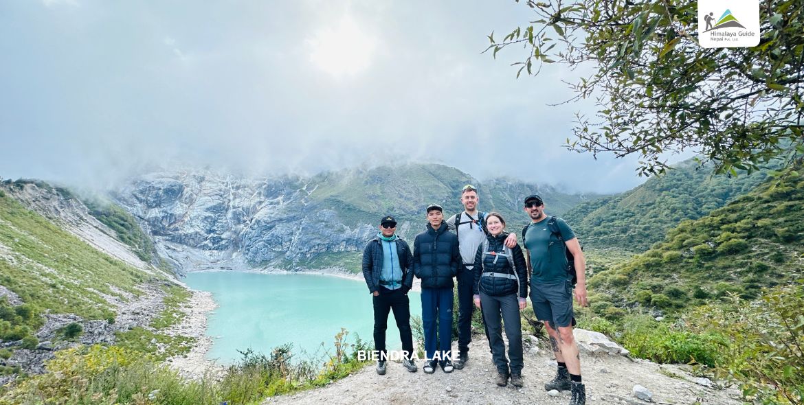
 The trek opened in 1992 and has since gained popularity, largely due to its amazing natural beauty and pristine surroundings. The trek takes place near the Nepal-Tibet border; therefore, you can see a blend of Hindu and Buddhist cultures along the trail. You will hike through nice forests filled with rhododendron, pine, cedar, birch, and juniper trees, as well as beautiful meadows.
As you continue along the Manaslu route, you will notice a marked change in the land formation, as you will see distinct river gorges cut by the Budhi Gandaki River. The suspension bridges will sway slightly over the roaring river as you cross from one village to the next, both villages on their respective hill sides. With each turn you take, the sheer beauty of the snow-capped peaks before you, of Manaslu included, will leave you speechless with awe and admiration. Prayer flags will blow with the wind, carrying mantras and blessings to the next valley as you make your way through, and there are old monasteries that leave you seeing and understanding how important this part of the world is in relation to growth, spirituality, and connection. Additionally, it is mandatory to bring microspikes or crampons for the trek. For connectivity, we recommend using an NTC SIM, as it provides better coverage in remote areas.
Highlights: What You Should Not Miss in the Manaslu Circuit Trek
- Get the stunning views of the mountains in the Manaslu Circuit Trek, like Mt Annapurna II, Lamjung Himal, and Mount Manaslu (8,156m).
- Immerse yourself in the unique culture and traditions of remote Gurung and Tibetan communities.
- Traverse the challenging yet rewarding Larkya La Pass (5,106m/16,752ft).
- Explore the pristine beauty of the less crowded and off-the-beaten-path trails.
- Discover ancient monasteries and prayer flags fluttering in the mountain breeze.
- Enjoy the warm hospitality of the local teahouses along the route.
- Hike through the dramatic Budhi Gandaki River gorge.
- Experience different types of environments, such as damp tropical rainforests and dry alpine meadows.
- Encounter a diverse array of flora and fauna, including the rhododendron forest and hundreds of bird species.
Create lifelong memories while trekking through an unbelievably stunning and culturally rich area.
Manaslu Circuit Trek Outline Itinerary
| Route | End Elevation | Elevation Gain/Loss | Duration | Distance |
|---|---|---|---|---|
| Day 01: Arrival at Tribhuvan International Airport, Kathmandu | 1,350 m | |||
| Day 02: Drive from Kathmandu to Machha Khola (869 m) via Sotikhola | -481 m (approx.) | |||
| Day 03: Trek from Machha Khola (869 m) to Jagat (1,400 m) via Khorla Bensi | +531 m | 5-6 hours | Approximately 22 km | |
| Day 04: Trek from Jagat (1,400 m) to Deng (1,750 m) via Sirdibas | +350 m | 6-8 hours | Approximately 20 km | |
| Day 05: Trek from Deng (1,750 m) to Namrung (2,660 m) via Bihi Phedi | +910 m | 6-8 hours | 19-21 km | |
| Day 06: Trek from Namrung (2,660 m) to Lho (3,180 m) via Lihi | +520 m (approx.) | 4-5 hours | Approximately 10 km | |
| Day 07: Trek from Lho (3,180 m) to Samagaun (3,525 m) via Syala | +345 m | 3-4 hours | 17.2 km | |
| Day 08: Acclimatization day in Samagaun (3,525 m) | ||||
| Day 09: Trek from Samagaun (3,525 m) to Samdo (3,875 m) | +350 m | 4-5 hours | 16.4 km | |
| Day 10: Trek from Samdo (3,875 m) to Dharamsala (4,460 m) via Larkye Bazaar | +585 m | 3-4 hours | 11.7 km | |
| Day 11: Trek from Dharamsala (4,460 m) to Bimthang (3,590 m) via Larkya La Pass (5,160 m) | -870 m | 8-10 hours | 24.7 km | |
| Day 12: Trek from Bimthang (3,590 m) to Tilije (2,300 m) via Yak Kharka and Gho | -1,290 m | 6-8 hours | 20-25 km | |
| Day 13: Trek from Tilije (2,300 m) to Besisahar (760 m) via Dharapani | -1,540 m (approx.) | 6-8 hours | Approximately 14 km | |
| Day 14: Drive from Besisahar (760 m) to Kathmandu (1,350 m) | +590 m |
Manaslu Circuit Trek Itinerary Breakdown
Arrival at Tribhuvan International Airport, Kathmandu
Highest Altitude
1,350 m
Welcome to Nepal and the mighty Himalayas! Upon arrival at the airport, our team will be there to greet you and assist with your transfer to your hotel, where you can relax and recover from your journey. After some time to rest and refresh, we will return to your hotel to provide a detailed briefing about the incredible Manaslu Circuit Trek you are about to embark on. This trek offers amazing views, cultural experiences, and scenery that make Nepal so popular, and it’s just the beginning of your travels!
Drive from Kathmandu to Machha Khola (869 m) via Sotikhola
Drive Distance
140-160 km
Drive Duration
8-10 hours
Highest Altitude
-481 m (approx.)
Meals
B+L+D
Accommodation
Hotel Nirvana /Hotel EVEREST
The journey from Kathmandu to Machha Khola (869 m) via Sotikhola involves a scenic yet challenging drive of approximately 140-160 kilometers, typically taking 8-10 hours. The initial stretch from Kathmandu follows well-paved roads towards Dhading Besi and Arughat. However, the route beyond Arughat, especially towards Sotikhola (approximately 730 m) and further to Machha Khola, becomes increasingly rugged, with unpaved, bumpy roads and a high risk of landslides, particularly during the monsoon season. Travelers usually opt for local buses or private/shared jeeps from Kathmandu, passing through picturesque landscapes of hills, rivers, and small settlements before reaching Machha Khola, the gateway to the Manaslu region treks.
Trek from Machha Khola (869 m) to Jagat (1,400 m) via Khorla Bensi
Trek Distance
Approximately 22 km
Trek Duration
5-6 hours
Highest Altitude
+531 m
Meals
B+L+D
Accommodation
New Mongolian Cottage & Restaurant
Day two of the Manaslu Circuit trek takes you from Machha Khola (869 m) to Jagat (1,400 m), a journey of approximately 5-6 hours covering around 22 km. The trail initially descends to cross the Tharo Khola before reaching the Gurung village of Khorla Bensi (970 m), offering views of waterfalls and the surrounding hills. From there, you’ll continue through forests, cross a suspension bridge over the Budhi Gandaki River, and perhaps stop at the Tatopani hot springs for a relaxing break. The path then involves some uphill trekking, passing through Dobhan and eventually leading to the picturesque village of Jagat, the entry point to the Manaslu Conservation Area, characterized by traditional stone houses and paved streets.
Trek from Jagat (1,400 m) to Deng (1,750 m) via Sirdibas
Trek Distance
Approximately 20 km
Trek Duration
6-8 hours
Highest Altitude
+350 m
Meals
B+L+D
Accommodation
Hotel Windy Valley & Garden
Day three of the Manaslu trek takes you from Jagat (1,400 m) to Deng (1,750 m), a distance of approximately 20 kilometers that typically takes 6-8 hours. The trail ascends over a ridge to Salleri, offering views of Shringi Himal, before descending towards Sirdibas. Continuing through the Budi Gandaki gorge, you’ll pass through the Gurung village of Philim, known for its terraced fields, and cross several suspension bridges. The path then leads through bamboo forests, eventually bringing you to the small Buddhist village of Deng, situated on the west bank of the Budi Gandaki River.
Trek from Deng (1,750 m) to Namrung (2,660 m) via Bihi Phedi
Trek Distance
19-21 km
Trek Duration
6-8 hours
Highest Altitude
+910 m
Meals
B+L+D
Accommodation
Namrung Guest House
On the fourth day of the Manaslu trek, you will start your hike from Deng (1,750 m) to Namrung (2,660 m). This is a significant gain in altitude, so pace yourself and allow plenty of time for the uphill climb and altitude gain. The trek starts with a steep ascent, followed by a descent to the same level as the Budi Gandaki River; You will traverse across and through the valley and villages, passing some small hamlets, Mani stones, and noticing that the Tibetan Buddhist influence is increasing in the region. You will be continuing to walk through beautiful landscapes, past the villages of Rana and Bihi Phedi. Whenever the altitude climbs up the final ascent to Namrung, you reach another village and enjoy the mountaintop scenery, including opportunities for acclimatization as well.
Trek from Namrung (2,660 m) to Lho (3,180 m) via Lihi
Trek Distance
Approximately 10 km
Trek Duration
4-5 hours
Highest Altitude
+520 m (approx.)
Meals
B+L+D
Accommodation
Majestic Manaslu Cottages & Café
On Day Five of the Manaslu trek, you will leave Namrung (2,660 m) and trek to the village of Lho (3,180 m). You will cover approximately 10 km in 4-5 hours. The initial trail to Lho is uphill, and you will have amazing views of Mt. Manaslu (8,163 m) and Naike peak. You will also pass through the village of Lihi, which is known for its traditional houses and Hinang Gompa, a structure that reflects both local cultural and Buddhist values. The route features forests of fir, rhododendron, and oak trees, with mani walls, while Lho boasts significant cultural value with its gompa and large mani wall.
Trek from Lho (3,180 m) to Samagaun (3,525 m) via Syala
Trek Distance
17.2 km
Trek Duration
3-4 hours
Highest Altitude
+345 m
Meals
B+L+D
Accommodation
Mount Manaslu Hotel & Lodge
Day six of the Manaslu trek takes you from the charming village of Lho (3,180 m) towards the larger settlement of Samagaun (3,525 m), with a pleasant stop at Syala along the way. This relatively shorter trek, typically lasting 3-4 hours, allows for a gradual ascent through beautiful alpine landscapes. You’ll traverse through forests and meadows, enjoying panoramic views of the majestic surrounding peaks, including the impressive Manaslu. Syala offers a serene break point to rest and soak in the scenery before continuing on a relatively easy trail to reach Samagaun, a village with a strong Tibetan Buddhist culture where you’ll likely spend a couple of nights for acclimatization.
Acclimatization day in Samagaun (3,525 m)
Meals
B+L+D
Accommodation
Mount Manaslu Hotel & Lodge
Day seven in Samagaun (3,525 m) is a crucial acclimatization night. It allows your body to adjust to the higher altitude and thinner air of the Himalayas. Rather than the usual day to climb higher, you will rest the afternoon and day with fewer strenuous activities. Although there is a good chance you will not be climbing any higher, you will still want to take short, easy day hikes to nearby viewpoints or, if you prefer, spend some time in the local culture by visiting monasteries or chatting with the nice locals. You will need to stay hydrated, eat well, and avoid strenuous activity on your acclimatization day, as this will help your body acclimate to the higher elevations.
Trek from Samagaun (3,525 m) to Samdo (3,875 m)
Trek Distance
16.4 km
Trek Duration
4-5 hours
Highest Altitude
+350 m
Meals
B+L+D
Accommodation
Zambala Hotel
Day eight in Samagaun (3,525 m) is a crucial acclimatization night. It allows your body to adjust to the higher altitude and thinner air of the Himalayas. Rather than the usual day to climb higher, you will rest the afternoon and day with fewer strenuous activities. Although there is a good chance you will not be climbing any higher, you will still want to take short, easy day hikes to nearby viewpoints or, if you prefer, spend some time in the local culture by visiting monasteries or chatting with the nice locals. You will want to stay hydrated, eat well, and avoid strenuous activity on your acclimatization day, as this will help your body acclimate to the higher elevations.
Trek from Samdo (3,875 m) to Dharamsala (4,460 m) via Larkye Bazaar
Trek Distance
11.7 km
Trek Duration
3-4 hours
Highest Altitude
+585 m
Meals
B+L+D
Accommodation
Hotel Larke Peak
Day nine of the trek involves the ascent from Samdo (3,875 m) to Dharamsala (4,460 m), also known as Larkye Phedi, which takes 3-4 hours of walking (a fairly short day). The trail is an ascent up a relatively gentle slope, providing an opportunity to acclimatize to the high altitude. You’ll walk through yak pastures and be treated to wider views of the mountains. The day’s walk will also take you through Larkye Bazaar, a seasonal Tibetan market and a historical place of interest on the route, but it may offer few signs of its existence these days. Today’s trek is important for both rest and preparation for the next day’s demanding trek, as well as to prepare yourself for what is to come tomorrow, the highest and toughest ascent of the trek over the Larkya La Pass.
Trek from Dharamsala (4,460 m) to Bimthang (3,590 m) via Larkya La Pass (5,160 m)
Trek Distance
24.7 km
Trek Duration
8-10 hours
Highest Altitude
-870 m
Meals
B+L+D
Accommodation
Hotel Ponkar Mountain & Restaurant
Today on the Manaslu Circuit trek, we move on towards a challenging yet rewarding journey, beginning with an early departure from Dharamsala (4,460 m) to cross the Larkya La Pass (5,160 m), the trek’s highest point. The steep ascent takes about 4-5 hours over rocky and possibly icy terrain, testing our endurance at high altitude. The pass offers breathtaking views of Manaslu, Annapurna II, and Himlung Himal. The descent to Bimthang (3,590 m) is equally demanding, taking another 4-5 hours down a steep, slippery trail through grassy moraine before a well-deserved rest in the valley.
Trek from Bimthang (3,590 m) to Tilije (2,300 m) via Yak Kharka and Gho
Trek Distance
20-25 km
Trek Duration
6-8 hours
Highest Altitude
-1,290 m
Meals
B+L+D
Accommodation
Hotel Larke Peak/ Hotel The North Face & Restaurant
On the eleventh day of the Manaslu Circuit trek, you’ll descend from Bimthang (3,590 m) to Tilije (2,300 m), passing through Yak Kharka (4,020 m) and Gho (2,560 m). The trek starts by crossing the Bhimthang glacier, offering mountain views, before descending through alpine forests to Gho. The final stretch follows the Marshyangdi River to Tilije, a charming Gurung village that introduces you to the unique culture of the Annapurna region. This segment covers approximately 20-25 kilometers and takes around 6-8 hours, shifting from high alpine terrain to subtropical landscapes.
Trek from Tilije (2,300 m) to Besisahar (760 m) via Dharapani
Trek Distance
Approximately 14 km
Trek Duration
6-8 hours
Highest Altitude
-1,540 m (approx.)
Meals
B+L+D
Accommodation
Hotel Yumpo & Café
Today’s walk involves a major decline; we are going from Tilije (2,300 metres) to Besisahar (760 metres). The usual three-day trek is to Dharapani (approximately 1,860 metres) and then to Besisahar by one means or another due to the distance and elevation difference. The walk from Tilije to Dharapani offers an excellent range of landscapes and cultural diversity through different zones of vegetation and villages inhabited by various ethnic groups.
Drive from Besisahar (760 m) to Kathmandu (1,350 m)
Drive Distance
175 km (approx.)
Drive Duration
6-8 hours
Highest Altitude
+590 m
Meals
B+L
Accommodation
Guest Own
Today marks the final leg of the trip, a beautiful drive from Besisahar, located at 760 meters, to Kathmandu, situated at approximately 1,350 meters. This approximately 175-kilometer journey is often completed in 6-8 hours as we travel along winding mountain roads, by rivers, through rural settlements, and experience the diverse landscapes of Nepal as we move into the Kathmandu Valley.
Inclusion/Exclusion in Manaslu Circuit Trek
Cost Includes
- International airport pick-up and drop-off service.
- 2 Nights’ accommodation in Kathmandu on a BB Plan.
- Bus ticket to Machha Khola by public bus.
- Tilche to Besisahar by public jeep.
- Public deluxe bus back to Kathmandu.
- Drop in a hotel in Kathmandu.
- Three meals a day (Breakfast, Lunch, and Dinner along the trek).
- Lodge accommodation on the way (common toilet and bathroom).
- License holder guide (including their salary, equipment, insurance, lodging, and food).
- Equipment: Down Jacket, Sleeping Bag.
- Manaslu Conservation Area Project Permit (MCAP).
- Manaslu Special Area Permit.
- Tsum Nupri Local Government Entrance Fee.
- Annapurna Conservation Area Project Permit (ACAP).
- All government VAT.
- Manaslu trekking map
- Trekking duffle bag, if needed.
- First aid medical box including an oximeter.
- Fresh and dry fruits along the trek.
- Token of love from the company.
- Farewell dinner/Nepali Food
Cost Excludes
- Extra night accommodation in Kathmandu.
- Travel insurance in case of emergencies during the trek.
- Cold drinks such as Coke, Mineral Water, Beer, etc.
- Hot drinks during the trek.
- Porter (We are happy to organize on request)
- Personal expenses (laundry, telephone, extra helper, battery charge shower, and boiled water).
- Tips are expected.
Manaslu Circuit Trek Map
Departure
14 Days
Trip Days
21 Nov, 2025
Start Friday
3 Dec, 2025
End Wednesday
0
Pax Booked
20
Group Size
USD 876
Price
Booking Open
Status
Prefer a more personal journey? Our private packages offer flexible dates, custom itineraries, and dedicated support—perfect for those seeking a tailored travel experience.
Image Gallery
Click! Click! Our Memories with Manaslu Circuit Trekkers
Manaslu Circuit Trek Trip Information
Packing List for Manaslu Trek
Clothing
- Base Layers
- Insulation layers
- Outer Shell
- Trekking pants and shirts
- Undergarments,
- Socks,
- Gloves
- Hats
- Buffs
Footwear
- Trekking Boots,
- Camp shoes/sandals
- Warm Socks,
- Gaiters
- Extra shoelaces
- Comparing
Manaslu Circuit Trek Permit
To trek the Manaslu Circuit legally, you need to obtain three major permits. Since it is a restricted region, you will need to obtain a Manaslu Restricted Area Permit (MRAP). The other two permits are the Manaslu Conservation Area Permit (MCAP) and the Annapurna Conservation Area Permit (ACAP). Depending on the nationality, the table below provides the prices of the permits:
| Permit Type | Required Documents | Cost (Foreign Trekkers) (per person) | Cost (SAARC Trekkers)(per person) | Cost (Local People) |
|---|---|---|---|---|
| Manaslu Restricted Area Permit (MRAP) | Passport copy, TIMS card, Travel insurance, Guide details | September – November
December – August
|
N/A | |
| Manaslu Conservation Area Permit (MCAP) | Passport copy, TIMS card (if applicable) | NPR 3,000 (≈ $25) | NPR 1,000 (≈ $8) | NPR 100 |
| Annapurna Conservation Area Permit (ACAP) | Passport copy (if applicable) | NPR 3,000 (≈ $25) | NPR 1,000 (≈ $8) | NPR 100 |
Note: You need to apply for the restricted permit through the registered trekking company. Besides, the other two permits can be obtained from the Nepal Tourism Board office or the entry point. And, if you are entering the Tsum Valley, you must obtain the Tsum Nupri Rural Municipality Permit, which costs USD 8 per person.
Manaslu Circuit Trek Trails
The Manaslu Circuit trek starts when you arrive in Kathmandu, the lively capital city located at an altitude of 1,350 meters. The next day, you will begin your overland journey. You will be driven from Kathmandu to Machha Khola (869 m) via Sotikhola. This scenic drive prepares you for the trekking adventure ahead, taking you from the busy city to the quieter landscapes of the Gorkha region.
The trekking itself officially kicks off from Machha Khola, with trails winding through picturesque valleys and alongside the Budhi Gandaki River. Over the next few days, you’ll ascend through charming villages like Jagat (1,400 m), Deng (1,750 m), Namrung (2,660 m), and Lho (3,180 m), each offering unique cultural insights and stunning mountain vistas. The trail progressively gains altitude, allowing for acclimatization as you immerse yourself in the local way of life and the breathtaking natural beauty.
A crucial acclimatization day is scheduled in Samagaun (3,525 m) to prepare your body for the higher elevations ahead. Following this rest, the trek continues towards Samdo (3,875 m) and then to Dharamsala (4,460 m), culminating in the challenging yet rewarding crossing of the Larkya La Pass (5,160 m). Descending from the pass, you’ll trek through Bimthang (3,590 m) and eventually make your way down to Tilije (2,300 m) and Dharapani, before concluding your trek in Besisahar (760 m). From Besisahar, a drive will return you to Kathmandu, completing the remarkable Manaslu Circuit journey.
Why Experience Manaslu Circuit Trek?
The Manaslu Circuit Trek invites adventurers who seek an authentic, remote, and challenging Himalayan experience that is not easily found on the crowded Everest and Annapurna trails. The trek follows a route that encircles Mount Manaslu, the world’s eighth-highest peak, and traverses many distinct ecosystems, ranging from lush subtropical forests to high alpine meadows and over the high and majestic Larkya La pass. The trek combines the beauty of the Great Himalayas with a rich cultural experience in one of Nepal’s less-visited areas.
Off-Beaten Trekking Trail in Nepal
If you like the remote, less trodden, off-beaten trekking trail in Nepal, then the Manaslu Circuit Trek is the way to go. The remoteness enables you to enjoy a more intimate experience with the awe-inspiring nature and culture of the local Gurung people. You will trek along remote valleys, cross swaying suspension bridges over rivers gushing with water, and visit traditional villages that have remained faithful to ancient traditions and the slow pace of life. This experience represents an aspect of Nepal that is largely devoid of mass tourism.
Larkya La Pass (5,106 m)
One of the main highlights and challenges of the Manaslu Circuit is crossing the Larkya La pass. This pass is high, at 5,106 meters (about 16,752 feet). It requires good physical fitness and time to adjust to the altitude. However, the amazing views from the top make the effort worthwhile. From Larkya La, you will see a beautiful scene of snow-covered peaks, including Manaslu and Annapurna II, along with other tall mountains in the Himalayas. This creates a memorable and inspiring experience.
Mount Manaslu | World’s Eighth-Highest Mountain
The trek offers stunning views of Mount Manaslu, the eighth-highest mountain in the world. Manaslu reaches an elevation of 8,163 meters (26,781 feet). You will walk around this magnificent peak to take in its splendor from different times and perspectives, enjoying unique views of its snow-covered slopes. The size and presence of Manaslu dominate the skyline for most of the trek, offering a constant perspective on the sheer power and beauty of the Himalayan range.
Least Crowded Trails
Manaslu Circuit is one of Nepal’s least crowded trekking trails. This means a more peaceful and enjoyable trek. You can truly appreciate the natural beauty and culture of the area without the crowds of trekkers around you. A less crowded trail allows for a more genuine feeling of exploration and discovery as you trek through the quiet trails and interact with local communities. This makes a trek on the Manaslu Circuit a special and unique one in the Himalayas.
Manaslu Circuit Side Trip
Phungen Monastery
Located above the Shyala village, Phungen Monastery lies at an elevation of 4,060 meters. It’s a 2–3 hour uphill hike from Shyala, ideal as an acclimatization day trip from Samagaon on the journey to the Manaslu Circuit. More than just a monastery, the location offers some of the most underrated panoramic viewpoints in the entire Manaslu region. The astonishing view of Mount Manaslu, Himalchuli, Ngadi Chuli, and surrounding glaciers is the highlight point seen from the monastery, making the side trip worthwhile.
Birendra Lake
At an elevation of 3,450 meters above sea level, Birendra Lake is another ideal location for a side trip on the Manaslu Circuit. It is a stunning glacier lake, fed by Mount Manaslu, and lies just a 45-minute walk from Samagaon. It is a serene and less crowded location surrounded by Mount Manaslu, providing refreshment from the long days of trekking. Additionally, you can combine the lake hike with a trip to Mt. Manaslu Base Camp (4,870m) to make the side trip even more remarkable.
Rui La Pass
Rui La Pass (4,998m) is a historical trade route between Nepal and Tibet and is a lesser-known side trip on the Manaslu Circuit Trek route. From Samdo, a full-day hike leads to the Pass, which is the closest point on the trekking route to Manaslu, where you can legally reach the Tibetan border. Moreover, the Pass lies beyond Lajyung Bhanjyang and requires a long day hike of around 7–8 hours in a round trip, making it a rarely visited side trip location.
Serang Gompa
Serang Gompa, also spelled Shringi, is located at an altitude of 3,100 meters and is accessible from Bihi Phedi or Prok village. It is a secluded and ancient Tibetan Buddhist monastery located on the hillside. It is a must-visit side trip for those who are interested in meditation, monastic life, and ancient Tibetan traditions. Yet, taking the side trip requires an additional day, making it optional.
Why is the Manaslu Circuit Trek Restricted?
The Manaslu Circuit Trek is one of the most stunning trek routes, offering cultural experiences, but it is located in a restricted region of Nepal. There are several reasons why access to Manaslu is restricted, including the protection of natural resources, cultural preservation, and environmental conservation. The restrictions help maintain the pristine condition of the Manaslu Conservation Area, while also promoting sustainable tourism in the area. So let’s get into it.
Preservation of local culture
The trek passes through villages with indigenous peoples. They have many traditions, languages, and lifestyles that have remained largely unchanged in their isolation. Tourism that is not well managed can impact their way of life and commodify their traditions for consumption, which may threaten their cultural authenticity. By limiting access, we help preserve their cultural integrity and create an opportunity for respectful interactions.
Environmental Conservation
A second reason for restricting access to the Manaslu region is to protect the various natural habitats. The Manaslu region encompasses a diverse range of ecosystems, including low-lying subtropical forests, montane shrublands and forests, and alpine forests. When tourism remains unrestricted, it can create issues, including deforestation, waste pollution, loss of habitat for wildlife, and damage to the ecological system. The use of a restricted permit allows us control over the number of trekkers. By controlling numbers, we mitigate the environmental impact of tourism and can also support conservation efforts in the Manaslu Conservation Area.
Supporting Sustainable Tourism
The restricted permit system restricts the number of trekkers allowed on the circuit at a given time. This enables sustainable tourism, which supports the local economy while minimizing pressure on the region’s infrastructure and resources. The permit fees typically support local development initiatives, conservation efforts, and improvements to trekking tracks and facilities. This is how tourism creates a good impact on local communities and the environment.
Ensure Trek Safety and Security
The Manaslu Circuit is a challenging trek with high mountain passes, remote trails, and unpredictable weather conditions. When emergencies arise, searches and recoveries can be delayed and dangerously complicated. A permit system ensures that trekkers can go with licensed guides who are familiar with the area, aware of safety regulations, and knowledgeable about emergency protocols. This provides trekkers with increased safety and security during their trek.
Managing Infrastructure and Resources
The infrastructure in the remote Manaslu region, including teahouses and trails, is not extensive and can easily be overwhelmed by large numbers of tourists. While controlling the number of tourists doesn’t necessarily eliminate overcrowding, it helps limit the number of visitors, thereby ensuring that the available capacity can accommodate the trekkers. Therefore, limiting the number of trekkers results in a better and ultimately more sustainable trekking experience for everyone.
Manaslu Circuit Trek Itinerary in a Nutshell
| Day | Activity | Altitude (m) |
|---|---|---|
| Day 01 | Arrival at Tribhuvan International Airport, Kathmandu | 1,350 |
| Day 02 | Drive from Kathmandu to Machha Khola via Sotikhola | 869 |
| Day 03 | Trek from Machha Khola to Jagat via Khorla Bensi | 869 – 1,400 |
| Day 04 | Trek from Jagat to Deng via Sirdibas | 1,400 – 1,750 |
| Day 05 | Trek from Deng to Namrung via Bihi Phedi | 1,750 – 2,660 |
| Day 06 | Trek from Namrung to Lho via Lihi | 2,660 – 3,180 |
| Day 07 | Trek from Lho to Samagaun via Syala | 3,180 – 3,525 |
| Day 08 | Acclimatization day in Samagaun | 3,525 |
| Day 09 | Trek from Samagaun to Samdo | 3,525 – 3,875 |
| Day 10 | Trek from Samdo to Dharamsala via Larkye Bazaar | 3,875 – 4,460 |
| Day 11 | Trek from Dharamsala to Bimthang via Larkya La Pass | 4,460 – 3,590 (Pass: 5,160) |
| Day 12 | Trek from Bimthang to Tilije via Yak Kharka and Gho | 3,590 – 2,300 |
| Day 13 | Trek from Tilije to Besisahar via Dharapani | 2,300 – 760 |
| Day 14 | Drive from Besisahar to Kathmandu | 760 – 1,350 |
Weather and Temperature for Manaslu Circuit Trek
| Season | Months | Weather Conditions | Temperature Range (Day/Night) | Trekking Conditions |
|---|---|---|---|---|
| Spring | March – May | Mild, sunny days; occasional rain | 10°C to 20°C / -5°C to 5°C | Best for trekking, clear views, blooming rhododendrons |
| Summer (Monsoon) | June – August | Heavy rainfall, cloudy, leeches, landslides | 15°C to 25°C / 5°C to 10°C | Challenging due to mud, slippery trails, fewer trekkers |
| Autumn | September – November | Stable, dry, clear skies, best visibility/td> | 5°C to 15°C / -10°C to 0°C | Peak season, excellent weather, crowded trails |
| Winter | December – February | Very cold, snow at higher passes | -5°C to 10°C / -15°C to -5°C | Difficult due to snow, some teahouses closed, extreme cold |
Altitude Profile of Manaslu Circuit Trek
The Manaslu Circuit Trek involves significant elevation gains, with starting points located at altitudes of around 700-900 meters (2,300-3,000 feet), depending on the starting location, either Soti Khola or Machha Khola. After the trek begins, the gradual ascent continues, moving between different types of terrain, including subtropical forests, terraced fields, and alpine meadows. You should expect approximately a few hundred meters of change in altitude each day, since you’re generally moving towards progressively higher settlements and observations. With each ascent, it is crucial to monitor acclimatization, particularly since the trek includes rest days after reaching the highest location. This is because you want to avoid acute altitude sickness in the days that follow, which can occur at altitudes of around 3,500 meters, as seen in Sama Gaun.
The trek concludes with a challenging ascent before crossing the tough Larkya La Pass at an impressive elevation of approximately 5,106-5,213 meters (16,752-17,103 feet). This is the highest point on the Manaslu Circuit trek and is likely going to take quite a physical toll on you as well. After crossing the pass, the trail begins to descend slightly. Eventually, trekkers will return to elevations below 1,900 meters (6,200 feet), near the location of Dharapani, where the trek will conclude. This drastic change in altitude is one of the main features of the Manaslu Circuit trek, and the trek provides climactic variance and stunning scenery during the descent.
What does a typical day on the Manaslu Circuit Trek look like?
A “typical” day on the Manaslu Circuit Trek doesn’t follow a rigid hour-by-hour schedule, as the timing can vary based on the specific day’s destination, trail conditions, weather, and the group’s pace. However, here’s a general idea of what you can expect on a trekking day:
Morning (Around 6:00 AM – 8:00 AM):
- 6:00 – 7:00 AM: Wake up and pack your belongings.
You’ll typically wake up relatively early. After filling your duffel bag and daypack, you’ll prepare breakfast.
- 7:00 – 8:00 AM: Breakfast.
Breakfast is typically served at the teahouse and may include items such as porridge, eggs, toast, chapati, or local bread with jam and butter, accompanied by tea or coffee.
Late Morning to Afternoon (Around 8:00 AM – 12:00/1:00 PM):
- 8:00 AM: Start trekking.
After breakfast, you’ll begin the day’s trek. The duration and difficulty will vary from day to day. You’ll be walking at a steady pace, with occasional stops to rest, hydrate, and take photos.
- Mid-morning break (around 10:00 – 10:30 AM)
A short break to catch your breath, have a snack (energy bars, dried fruit, nuts you’ve brought), and drink water.
Midday (Around 12:00 PM – 2:00 PM):
- 12:00 – 1:00 PM: Lunch.
You’ll typically stop at a teahouse or designated spot along the trail for lunch. Lunch options include dal bhat (a traditional dish of lentils, rice, and vegetables), noodles, soup, or sandwiches.
- 1:00 – 2:00 PM: Continue trekking.
After lunch, you’ll resume the trek towards your destination for the day.
Late Afternoon (Around 2:00 PM – 5:00 PM):
- 2:00 – 4:00/5:00 PM: Arrive at the teahouse. You’ll typically arrive at your teahouse for the night in the mid-to-late afternoon.
- Settle in. Upon arrival, you will be shown to your room, which is usually a basic twin-sharing room with beds and blankets. You can unpack your daypack, freshen up, and take a moment to relax.
Evening (Around 5:00 PM – 9:00 PM):
- 5:00 – 6:00 PM: Rest and socialize. This is a great opportunity to rest your tired muscles, read a book, play cards with fellow trekkers, or simply take in the stunning mountain scenery.
- 6:00 – 7:00 PM: Dinner. Dinner is usually served in the common dining area of the teahouse. Like lunch, it will likely be a simple but filling meal. You can also order hot drinks, such as tea or hot lemon.
- 7:00 – 8:00 PM: Briefing for the next day. Your guide will usually provide a briefing about the next day’s trek, including the estimated walking time, altitude gain, and any critical information about the trail.
- 8:00 – 9:00 PM: Relax and prepare for sleep. Most trekkers turn in relatively early to get enough rest for the next day’s hike.
Is there a risk of altitude sickness on the Manaslu Circuit Trek?
There is a high risk of altitude sickness on the Manaslu Circuit Trek. This trek reaches great heights, with the highest point being Larkya La Pass at 5,106 meters (16,752 feet). Altitude sickness, also known as Acute Mountain Sickness (AMS), happens when your body struggles to adjust to lower oxygen levels at high altitudes. Symptoms can be mild, such as headaches, nausea, fatigue, dizziness, loss of appetite, and trouble sleeping. More severe symptoms can include High Altitude Pulmonary Edema (HAPE) and High Altitude Cerebral Edema (HACE), which can be life-threatening and require you to descend immediately. Here are some ways to deal with altitude sickness on a Manaslu Circuit Trek:
Gradual Ascent
The most crucial step in preventing altitude sickness is to ascend gradually. Your body needs time to adjust to the reduced oxygen levels at higher altitudes. Aim to increase your sleeping altitude by no more than 500 meters (1600 feet) per day once you are above 2500 meters (8200 feet). Spending a rest day at the same altitude allows your body to acclimate before moving to higher altitudes.
Hydration
Staying well-hydrated is vital. Lower air pressure at higher altitudes can lead to increased fluid loss through respiration and urination. Drink plenty of water and avoid excessive consumption of alcohol and caffeinated beverages, as these can dehydrate you further. Aim for light-colored urine as an indicator of adequate hydration.
Avoid Alcohol and Smoking
Alcohol can worsen the symptoms of altitude sickness, such as headache and nausea, and can also lead to dehydration. Smoking reduces the amount of oxygen your blood can carry, making it harder for your body to adapt to the lower oxygen levels at altitude. It’s best to avoid both alcohol and smoking, especially during the initial stages of acclimatization.
Light Meals
Opt for light, easily digestible meals, especially in the first few days at higher altitudes. Avoid heavy, fatty foods that can put extra strain on your digestive system. Carbohydrate-rich foods are often recommended as they require less oxygen for metabolism.
Pain Relief and Rest
Over-the-counter pain relievers like ibuprofen or acetaminophen can help alleviate headaches, a common symptom of mild altitude sickness. Getting adequate rest is also crucial to allow your body to adapt. Avoid strenuous activity during the first 24-48 hours at a new, higher altitude. If symptoms worsen despite these measures, descending to a lower altitude is the most effective remedy.
Guide and porters for Manaslu Circuit Trek
As the Manaslu region is classified as a restricted area, it is essential to have an experienced guide to assist you on your trek. Aside from being a legal requirement, a guide can also keep you safe from obstacles that appear along obscure and often remote trails. Your guide will assist you with navigating the dangers of landslides, altitude sickness, and emergencies. Your guide has resided in the region for many years and is familiar with the local landscape and weather, as well as the preparation systems that will best ensure your safe and successful expedition.
Of course, your guide will also enhance your experience of immersion in the local culture by assisting with communication with the local communities, sharing their culture and traditions, and offering information on the local history and environment you will encounter. They will enhance your trekking experience with more interesting and immersive activities.
Hiring a porter for the Manaslu Circuit trek is optional, but it will significantly enhance your experience. A porter will carry most of your equipment and supplies, which allows you to trek comfortably without the heavy backpack. The sheer relief and comfort of eliminating that weight from your stride will help tremendously, whether in good weather or bad, and especially on those long days that challenge you both physically and mentally. Carrying a heavy pack over long distances is draining and increases the risk of injury and strain.
Manaslu Circuit Trek Cost
Since the Manaslu Circuit Trek is located in a restricted area of Nepal, individual trekkers cannot plan the trek independently. There must be at least two trekkers, so the cost of this trek via a Himalaya guide is $876 per person. However, if trekkers decide to trek in a group, then they get a discount. For example, for a party of 10 people, the cost per person is $733. The cost for trekking in the Manaslu region includes several mandatory permits: the Manaslu Restricted Area Permit (MRAP), which varies by season, as well as the Manaslu Conservation Area Permit (MCAP) and the Annapurna Conservation Area Permit (ACAP).
Hiring a licensed trekking guide is also required, adding to your expenses. Other costs to consider are accommodation in teahouses, meals, transportation to and from the trek (Kathmandu to Soti Khola/Machha Khola and Dharapani/Besisahar back), personal trekking gear (available for purchase or rental in Kathmandu), travel insurance for high-altitude trekking, visa fees, and personal expenses like drinks, snacks, and tips for your guide and porters.
Transportation Cost:
Private Jeep (Comfortable, Flexible Timing)
| Route | Cost (USD) | Capacity |
| Kathmandu to Machha Khola | 195 | 7 seater |
| Tilche to Besisahar | 145 | 7 seater |
| Besisahar to Kathmandu | 180 | 7 seater |
Public Transportation (Budget Option)
| Route | Cost (USD) | Notes |
| Kathmandu to Machha Khola | 10 per seat | Local bus/jeep |
| Tilche to Besisahar | 20 per seat | Shared local jeep |
| Besisahar to Kathmandu | 10 per seat | Bus/microbus |
| Hotel to Bus Station | 10 per taxi | Shared by up to 3 people |
| Final Station to Hotel | $10 per taxi | Shared by up to 3 people |
Comparing Manaslu Circuit Trek with Upper Mustang Trek and Upper Dolpo Trek
| Feature | Manaslu Circuit Trek | Upper Mustang Trek | Upper Dolpo Trek |
|---|---|---|---|
| Location | Gorkha district, west of Kathmandu | Mustang district, north of Annapurna & Dhaulagiri | Dolpo district, far western Nepal |
| Highest Point | Larkya La Pass (5,106m / 16,752 ft) | Lo Manthang (approx. 3,800m / 12,467 ft) | Jungben La Pass (5,550m / 18,209 ft) (High Route) |
| Trek Duration | 10-14 days (excluding arrival/departure in Kathmandu) | 10-14 days (excluding arrival/departure in Kathmandu) | 18-28 days (including arrival/departure in Kathmandu) |
| Difficulty | Strenuous to Challenging | Moderate | Challenging to Very Challenging |
| Permits Required | Manaslu Restricted Area Permit (RAP), Manaslu Conservation Area Permit (MCAP), | Upper Mustang Restricted Area Permit (RAP), ACAP, | Upper Dolpo Restricted Area Permit (RAP), Shey-Phoksundo National Park Entry Permit, |
| Accessibility | Scenic drive from Kathmandu to the trek starting point | Fly to Jomsom from Pokhara, then trek or jeep | Fly to Nepalgunj, then Juphal, then trek |
| Scenery | Dramatic river gorges, waterfalls, diverse landscapes from subtropical to alpine, glaciers, and stunning mountain views, including Manaslu | Arid, desert-like landscape, deep canyons, eroded cliffs, colorful rock formations, views of the Annapurna and Dhaulagiri ranges | Rugged terrain, remote valleys, pristine lakes (like Phoksundo), high passes, unique flora and fauna |
| Culture | A mix of Hindu and Tibetan-influenced culture, the Nubri and Tsumba people | Strong Tibetan Buddhist culture, ancient monasteries, and unique traditions | Tibetan Buddhist culture, remote villages, and the Bon religion in some areas |
| Remoteness | Relatively remote, but teahouses are available | Remote, but teahouses are available on the main route | Very remote, requires camping for most of the trek |
| Crowds | Less crowded than the Everest or Annapurna regions | Moderate, becoming more popular | Very few trekkers, offering a sense of wilderness |
| Accommodation | Teahouses/lodges are available along most of the route | Teahouses/lodges are available along most of the route | Camping is essential, and there are some basic guesthouses in the lower areas |
| Best Time to Visit | Spring (March-May) and Autumn (September-November) | Spring (March-May) and Autumn (September-November). | Spring (May-June) and Autumn (September-October). |
| Altitude Sickness Risk | High due to crossing a high pass | Moderate, the highest point is lower | High due to multiple high passes and elevations |
| Trek Style | Teahouse trek | Teahouse trek (can also do jeep tours in parts) | Primarily a camping trek |
| Cost (2 pxx) | $876 per person | $1,559 per person | $3500 per person |
Depending on your scenery, culture, remoteness, and budget interests, each trek in Nepal is something unique to experience. Manaslu Circuit offers a combination of cultural exposure, diverse landscape, and a challenging high pass. Upper Mustang trek offers a distinct high-altitude desert with a touch of Tibetan Buddhism influence, and is more accessible. If you want wilderness and cultural purity in a remote setting, the Upper Dolpo trek, more difficult and costly, offers a memorable experience. Think about what on trekking matters most to you—breathtaking scenery, strong cultural immersion, high-altitude extremes, or peaceful trails—to help choose your perfect Himalayan experience.
Frequently Asked Questions: What else you should know?
1. Which trek is more popular, the Manaslu Circuit or the Annapurna Circuit Trek in Nepal?
2. Can you combine the Manaslu Base Camp Trek with the Tsum Valley Trek?
3. What are some of the important places to trek around the Manaslu region?
4. Considering the remoteness, what are the typical communication options available for the Manaslu Circuit Trek?
5. What are the positive and negative economic and cultural impacts of tourism in the Manaslu region?
6. What is the highest altitude reached on the Manaslu Circuit trek?
7. How can I prevent altitude sickness during the Manaslu Circuit Trek?
8. What are some of the cultural highlights of the trek?
9. How physically fit do I need to be for the Manaslu Circuit Trek?
10. Is travel insurance recommended for the Manaslu Circuit Trek?
Travellers Reviews