
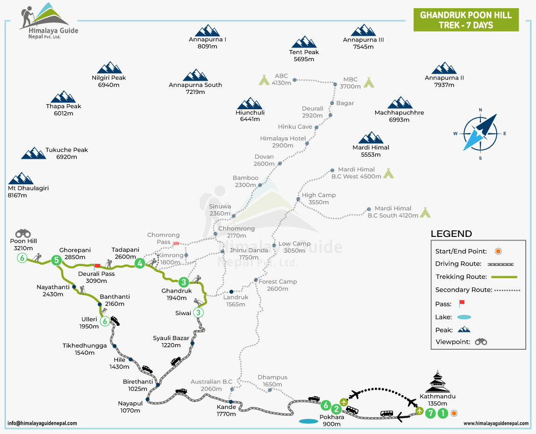
The Ghandruk Poon Hill Trek Map provides a visual understanding of the trekking journey. It helps you understand the route, key locations, and overall layout before and during the trek. It highlights the major villages, route connections, viewpoints, and other important landmarks along the route.
For a short adventure like the Ghandruk Poon Hill Trek, having a map makes it easier to understand how the different sections connect over a short distance. It can also help you plan daily walking distances, check the trail direction, identify nearby landmarks, and better understand the surrounding geography and elevation.
Ghandruk Poon Hill Trek Map Quick Facts
- Region: Annapurna Region, Nepal
- Duration: 7 Days
- Trek Starting Point: Nayapul
- Major Villages: Ghandruk, Tadapani, Banthanti, Ghorepani, Ulleri
- Highest Point: Poon Hill (3,210 m / 10,531 ft)
- Trekking Distance: 35-45 km
- Main Route: Ulleri → Ghorepani → Poon Hill → Tadapani
- Trek Difficulty: Easy
- Daily Walking Time: Around 4–6 hours
- Major Highlights: Poon Hill sunrise, Annapurna & Dhaulagiri views, Ghandruk village, rhododendron forests
- Trek End Point: Ulleri → Drive to Pokhara
Ghandruk Poon Hill Short Trek Route
| Route | Duration | Distance |
|---|---|---|
| Nayapul → Ghandruk | 5–6 hours | ~11 km |
| Ghandruk → Tadapani via Bhaise Kharka | 4–5 hours | ~8 km |
| Tadapani → Ghorepani via Banthanti | 5–6 hours | ~8 km |
| Ghorepani → Poon Hill → Ulleri | 5–6 hours | ~12 km |
| Total Trekking Route | 19–23 hours | ~39 km |
How to Read a Ghandruk Poon Hill Trek Map
The Ghandruk Poon Hill Trek map is easy to read once you understand its basic symbols and signs. The legend is your helpful tool at the bottom left of the map. It shows what each symbol, line, and color represents, making it easier to identify the route, villages, viewpoints, roads, and other important landmarks.
| Symbol | Meaning | What it shows on the map | Details |
|---|---|---|---|
| The orange circle | Starting or finishing location | Where the trek begins or ends | Kathmandu |
| The black and white dashed line | Road/vehicle route | Sections traveled by bus, jeep, or other vehicle | Kathmandu to PokharaPokhara to Ulleri Siwai to PokharaPokhara to Kathmandu |
| The green solid line | Main trekking trail | The primary walking route of the trek | Ulleri → Ghorepani → Poon Hill → Tadapani → Ghandruk |
| The dotted gray line | Alternative trail | Optional or less-used trekking routes connected to the main trail | Annapurna Base Camp |
| The red flag | Mountain pass | A high crossing point between valleys or mountains | Deurali Pass |
| The blue oval represents a lake | Lake | Natural lakes along or near the trekking route | Pokhara (Phewa Lake) |
| The mountain sign | Mountain peak | Major peaks visible or located near the route | Dhaulagiri, Tukuche Peak, Nilgiri, Annapurna South, Hiunchuli, Annapurna I, Machhapuchhre |
| The binocular symbol | Viewpoint | Places marked for panoramic mountain or landscape views | Poon Hill |
What You Can See Along the Short Poon Hill Trek Route
- Annapurna Range
Although the Ghandruk Poon Hill Trek is relatively short, it takes you through several locations offering impressive views of the Annapurna massif. The mountain views include Annapurna I, Annapurna South, Annapurna II, Annapurna III, and Annapurna IV.
- Dhaulagiri Range
The view of the Dhaulagiri massif becomes one of the major highlights from Poon Hill. During sunrise, the sight of the world’s seventh-highest mountain, Dhaulagiri I, alongside Nilgiri and Tukuche Peak, is especially impressive.
- Machhapuchhre/Fishtail
Machhapuchhre, also known as Fishtail Mountain, is one of the most recognizable peaks you can see during the Short Poon Hill Trek. With its sharp and pointed appearance, it is easy to identify along the route and from the viewpoint of Poon Hill.
- Rhododendron forests
Much of the Ghandruk Poon Hill Trek route passes through dense rhododendron forests, especially between Ghandruk, Tadapani, and Ghorepani. In spring, the forests become especially colorful when the rhododendrons bloom.
- Traditional villages
One of the key highlights of the Ghandruk Poon Hill Trek is the opportunity to walk through traditional Himalayan villages and experience their culture. You’ll pass through culturally rich villages like Ghandruk, Tadapani, and Ghorepani, where traditional architecture, local lifestyles, and cultural practices add to the trekking experience.
- Terraced hillsides
Along the way to Ghandruk Poon Hill, you’ll see green and cultivated terraces on many of the lower hillsides along the route. These fields reflect the traditional farming practices of local communities.
Short Ghandruk Poon Hill Trek Map FAQs
How long is the Short Ghandruk Poon Hill Trek?
Where does the Short Ghandruk Poon Hill Trek start?
What is the highest point shown on the Poon Hill Trek Map?
How far is Ghorepani from Poon Hill?
What villages are shown on the Ghandruk Poon Hill Trek Map?
Can I download the Short Ghandruk Poon Hill Trek Map?
Can the Short Ghandruk Poon Hill Trek be completed without a guide?


