Where is Bhutan?-the secrets of the kingdom in the Himalayas
UPDATED ON 4 March, 2024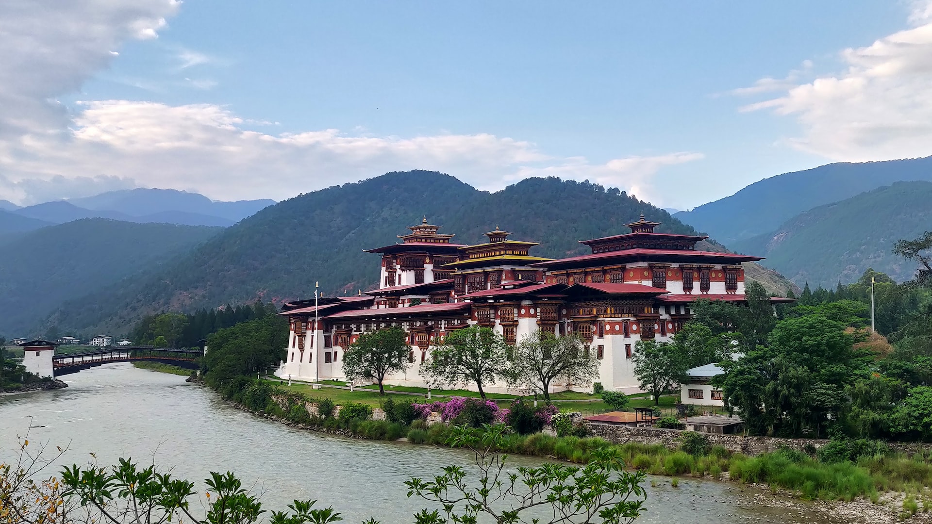
Where is Bhutan? Bhutan is a small, landlocked country in southern Asia that is located deep in the Himalayas between China and India. Bhutan, a historically secluded country, began to lose its isolation in the second part of the 20th century, which caused the rate of development to quicken.
A journey that traditionally required six days by mule could be completed in only a few hours by vehicle down a tortuous mountain road from the border town of Phuntsholing in the early 21st century thanks to advancements in transportation.
Enjoy the following trip to Bhutan: Bhutan Short Tour
The governmental setup also underwent a significant adjustment. Reforms started in the 1950s and 1960s by King Jigme Dorji Wangchuk (reigned 1952–72) resulted in a transition from absolute monarchy to multiparty parliamentary democracy in the 1990s and 2008.
The rich valleys of the Lesser Himalayas, which are divided from one another by several tall and intricately connected ridges running from north to south across the nation, are where Bhutan’s economic center is located.
The Paro and Thimphu valleys in the Lesser Himalayan region serve as Bhutan’s political hub. The country has significant geopolitical significance due to its location between the Plateau of Tibet in southwestern China to the north and the Assam-Bengal Plain of India to the south.
Land
Although it is unclear, Bhutan’s northern and western borders with the Tibet Autonomous Region (a province of China) largely follow the Great Himalayan crest. The border between Bhutan and the Indian states of West Bengal and Assam is located in the Duars Plain to the south of the Himalayan range. Bhutan shares boundaries with Sikkim and Arunachal Pradesh, two Indian provinces.
Himalayas of Bhutan
The Great Himalayas, which include Bhutan’s northern area, contain snow-capped peaks that rise to a height of more than 24,000 feet (7,300 meters). High valleys descend from the large northern glaciers at heights of 12,000 to 18,000 feet (3,700 to 5,500 meters).
Yaks are grazed in the summer in alpine pastures on the upper peaks. Many “marginal” mountains of the Tibetan Plateau, which are located to the north of the Great Himalayas, serve as the main watershed for rivers that travel north and south. The Great Himalayan region is characterized by a dry environment.
The Great Mountains’ pace of life remained almost unchanged until around 1960. Bhutanese traders brought back salt, wool, and occasionally herds of yaks while transporting cloth, spices, and grains into Tibet over mountain routes. However, the annexation of Tibet by China forced Bhutan to end its isolation; as a result, considerable changes were made to how people lived in those highlands as military preparations were taken to protect against the possibility of a Chinese assault from Tibet.
Different Himalayas Regions of Bhutan
The Great Himalayas
The Great Himalayas, which include Bhutan’s northern area. Contains snow-capped peaks that rise to a height of more than 24,000 feet (7,300 meters). High valleys descend from the large northern glaciers at heights of 12,000 to 18,000 feet (3,700 to 5,500 meters).
Yaks are grazed in the summer in alpine pastures on the upper peaks. Many “marginal” mountains of the Tibetan Plateau, which are located to the north of the Great Himalayas, serve as the main watershed for rivers that travel north and south. The Great Himalayan region is characterized by a dry environment.
The Great Mountains’ pace of life remained almost unchanged until around 1960. Bhutanese traders brought back salt, wool, and occasionally herds of yaks while transporting cloth, spices, and grains into Tibet over mountain routes.
However, the annexation of Tibet by China forced Bhutan to end its isolation; as a result, considerable changes were made to how people lived in those highlands as military preparations were taken to protect against the possibility of a Chinese assault from Tibet.
The Lesser Himalayas
The Lesser Himalayas are formed by spurs that radiate south from the Big Himalayas (also called Inner Himalayas). Similarly, the Lesser Himalayas’ north-south mountains serve as basins for Bhutan’s major rivers.
The predominant vegetation, which ranges from a dense forest on the rain-swept windward slopes to alpine vegetation at higher elevations, is determined by differences in elevation and the degree of exposure to wet southwest monsoon winds. With elevations ranging from 5,000 to 9,000 feet, the Lesser Himalayas have several lush valleys in central Bhutan (1,500 to 2,700 meters).
These valleys, particularly the Paro, Punakha, Thimphu, and Ha, are broad and flat, get considerable amounts of precipitation (between 40 and 50 inches, or around 1,000 and 1,270 millimeters) annually, and are largely populated and farmed.
The Duars Plain
The narrow Duars Plain, which constitutes a strip 8 to 10 miles (12 to 16 km) broad along Bhutan’s southern border, is located south of the Lesser Himalayas and their foothills. This plain serves as a doorway to the important mountain passes (known as Dwars or Dooars) that lead into the rich valleys of the Lesser Himalayas, where the Himalayan mountains rise abruptly and sharply.
The entire Duars tract receives a lot of rain (200 to 300 inches [5,100 to 7,600 mm] annually), is hot and humid, and is covered in thick semitropical forest and vegetation.
Climate of Bhutan
Perhaps more than any other comparable-sized region in the globe, Bhutan has a diverse climate. With elevation comes a difference in a climate that brings about pronounced meteorological contrasts. Moreover, different exposures to sunlight and moisture-laden winds provide intricate local variations.
Three main climatic regions may be distinguished: the Great Himalayan alpine tundra region, the Lesser Himalayan milder region, and the hot, humid subtropical tract of the Duars Plain and its surrounding foothills.
Only the valleys of the middle mountains experience a temperate climate. For instance, in January, the west-central city of Thimphu typically experiences highs in the low 50s F (about 12 °C) and lows in the mid-30s F (about 2 °C); in July, however, Thimphu experiences somewhat warmer temperatures, with highs typically reaching the mid-60s F (about 19 °C) and lows falling to the mid-50s F (about 13 °C). The rest of the nation either endures extreme cold, as in the north or intense heat, as in the Duars.
History of Bhutan
Bhutan has always been virtually inaccessible to outsiders due to its rough mountains and dense woods, and the country’s rulers furthered this isolation by forbidding foreigners until well into the 20th century.
Then, a gradual transformation started as a result of pressure from nearby nations having strategic interests in Bhutan. Bhutan started to build its international connections when it committed to strategies of social and administrative reform together with economic development.
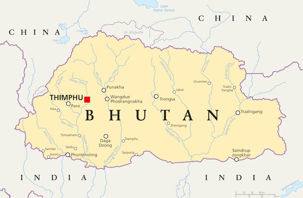
Where is Bhutan located on a Map?
Bhutan has always been virtually inaccessible to outsiders due to its rough mountains and dense woods, and the country’s rulers furthered this isolation by forbidding foreigners until well into the 20th century.
Then, a gradual transformation started as a result of pressure from nearby nations having strategic interests in Bhutan. Bhutan started to build its international connections when it committed to strategies of social and administrative reform together with economic development.
Capital city:
The main city in Bhutan is Thimphu, which is also the capital of the country. It is located in the western section of the country. It is one of the numerous Dzongkhags or Districts in the nation and is located within its valley, referred to as the Thimphu Valley. In 1955, Thimphu took over as the nation’s capital from Paro, and the monarch of Bhutan officially recognized it in 1961.
Total area:
Bhutan is a landlocked country that is relatively small compared to most of its close neighbors, having a total area of about 38,394 square kilometers (14,824 square miles). Bhutan has one of the lowest populations per square kilometer in the world, and its government has a policy of always keeping at least 65–70% of the nation as forests or woodlands.
Languages:
Bhutanese, often known as Dzongkha regionally, is one of the 53 Tibetic languages spoken in the Himalayas and is the country’s official language. Although Dzongkha is taught as the national language and is the traditional script in Bhutan, English is the primary language of teaching in all schools.
22 more languages, large variations of the original Dzongkha but also including Nepali, are spoken across the country. Tshangla, Dzala, Limbu, Keng, and Rai are further dialects that make up about 45% of Bhutan’s spoken languages.
Bhutan Location Map in Asia
Bhutan is a country located in the Asia continent. Which is the largest continent in the world. Bhutan is a country in what is officially classified as Asia but is more commonly referred to as South Asia. As Asia includes Russia as well, it is one of the largest continents on the globe.
Bhutan is located in the geographic center of Asia’s southern region. Bhutan is bordered by several Asian countries with various demographic backgrounds. Including China to the north and east, and India to the west. And the Indochinese region of Southeast Asia to the southeast.
Bhutan Location on World Map
Geologically speaking, Bhutan is located on the northernmost edge of the Indian Tectonic Plate. Which is in the middle of the southern region of the Asian Continent. Bhutan is a country of unparalleled ecological stability. Located between the latitudes of 26.71 degrees north and 28.33 degrees north.
And the longitudes of 88.77 degrees east and 92.13 degrees east. Moreover, Bhutan is an environmentalist’s paradise since it has the smallest carbon footprint ever—one that is negative.
Bhutan Outline Map
An irregularly shaped country, unlike its close neighbor Nepal, it is clear to understand why its northern border is shaped. So, it lies on the range of the Himalayas. Following the contours of the mountain range as it runs from west to east. The southern, western, and eastern borders of the kingdom are mainly defined by the demographics of the population of the kingdom. And are based on the areas in which the native peoples of Bhutan originated.

